Added on Jauary 12, 2013
United Nations/Croatia Workshop on
the Applications of Global Navigation Satellite Systems
Baška, Krk Island, Croatia, 21–25 April 2013
Introduction
A five-day workshop on global navigation satellite systems (GNSS) technology and its applications in Baška, Croatia, from 21 to 25 April 2013 is being organized by the United Nations Office for Outer Space Affairs (OOSA) in cooperation with the Faculty of Maritime Studies of the University of Rijeka as part of the activities of the United Nations Programme on Space Applications, for the benefit of the countries in Europe. The Workshop will be hosted by the Faculty of Maritime Studies of the University of Rijeka.
GNSS refers collectively to all of the satellite navigation systems in operation or being developed around the world known as the Global Positioning System (GPS) of the United States of America, the Global Navigation Satellite System (GLONASS) of the Russian Federation, Galileo of the European Union and Compass/BeiDou of China. In addition, these systems are supplemented by space-based augmentation systems (SBAS) or ground-based augmentation systems (GBAS). Examples of SBAS are the United States of America wide-area augmentation system (WAAS), the Russian system of differential correction and monitoring (SDCM), the European geostationary navigation overlay service (EGNOS), or the Indian GPS-aided geo augmented navigation (GAGAN) and the Japanese multi-functional transport satellite (MTSAT) space-based augmentation system (MSAS). These systems augment the existing medium earth orbit (MEO) satellite constellations with geostationary (GEO) or geosynchronous satellites signals or other environmental factors, which may impact the signal received by the users. Using several or all of the GNSS satellites in orbit, productivity typically increases as well as accuracy compared to using only one system.
Workshop participants will discuss how GNSS-enabling technology can strengthen a network of national reference stations and promote the interoperability of navigation, positioning and timing systems in the region. An overview of a wide range of GNSS applications existing today and prospects for the future, in areas such as surveying, mapping and asset management, precision agriculture, engineering and construction, aviation and maritime, as well as space weather monitoring will be provided.
"Information note" and "Application FORM" (in PDF and WORD format) were attached to ISWI Newsletter Vol.5 No.3
on-line application form is available here
(
)
Session 1: Current and planned global and regional navigation satellite systems and satellite-based augmentation systems
![]() Programme updates-GNSS: Global Positioning System (GPS Wiki), GLObal NAvigation Satellite System (GLONASS Wiki), European Satellite Navigation System (GALILEO Wiki), COMPASS/BeiDou Navigation Satellite Systems (CNSS Wiki), Indian Regional Navigation System (IRNSS Wiki), Quasi-Zenith Satellite System (QZSS Wiki)
Programme updates-GNSS: Global Positioning System (GPS Wiki), GLObal NAvigation Satellite System (GLONASS Wiki), European Satellite Navigation System (GALILEO Wiki), COMPASS/BeiDou Navigation Satellite Systems (CNSS Wiki), Indian Regional Navigation System (IRNSS Wiki), Quasi-Zenith Satellite System (QZSS Wiki)
![]() GNSS space-based augmentation systems: Wide-Area Augmentation System (WAAS), System of Differential Correction and Monitoring (SDCM), the European Geostationary Navigation Overlay Service (EGNOS), GPS Aided Geo-Augmented Navigation (GAGAN), the Multifunctional Transport Satellite Satellite-based Augmentation System (MSAS)
GNSS space-based augmentation systems: Wide-Area Augmentation System (WAAS), System of Differential Correction and Monitoring (SDCM), the European Geostationary Navigation Overlay Service (EGNOS), GPS Aided Geo-Augmented Navigation (GAGAN), the Multifunctional Transport Satellite Satellite-based Augmentation System (MSAS)
Session 2: GNSS user applications
![]() Space and atmospheric weather: observation of space weather phenomena through the deployment of ground-based world-wide instrument arrays such as GPS receivers, magnetometers, solar telescopes, very low frequency (VLF) monitors, solar particle detectors, and data analysis and the sharing of recorded data
Space and atmospheric weather: observation of space weather phenomena through the deployment of ground-based world-wide instrument arrays such as GPS receivers, magnetometers, solar telescopes, very low frequency (VLF) monitors, solar particle detectors, and data analysis and the sharing of recorded data
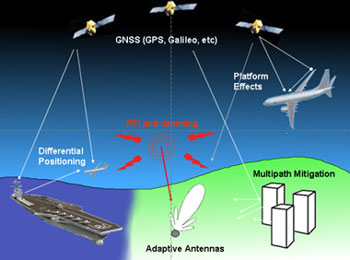
![]() New capabilities in efficiency and safety across all modes of transportation: aviation, maritime,
rail and highway
New capabilities in efficiency and safety across all modes of transportation: aviation, maritime,
rail and highway
![]() Applications in surveying and mapping, geodesy, science and timing, environment, agriculture,and remote sensing with GNSS and integrated sensors
Applications in surveying and mapping, geodesy, science and timing, environment, agriculture,and remote sensing with GNSS and integrated sensors
Session 3: GNSS reference station networks and services
![]() Regional and national reference frames/systems implementation
Regional and national reference frames/systems implementation
![]() International GNSS Service (IGS) and other initiatives, multi-GNSS environment
International GNSS Service (IGS) and other initiatives, multi-GNSS environment
Session 4: Capacity building, training and education in the field of GNSS
All Sessions: Discussion Sessions
![]() Issues, concerns and approaches for pilot projects/initiatives, requirements of implementing,
mechanisms and resources of implementing
Issues, concerns and approaches for pilot projects/initiatives, requirements of implementing,
mechanisms and resources of implementing
![]() Possible follow-up projects and initiatives and proposals for future workshops/training courses
Possible follow-up projects and initiatives and proposals for future workshops/training courses
close additional text