AFRL-SCINDAScintillation Network Decision AidThe Scintillation Network Decision Aid (SCINDA) is a real-time, data driven communication outage forecast and alert system developed for the United States Air Force Space Command by the Air Force Research Laboratory (AFRL), Ionospheric Hazards Branch, Hanscom AFB. Its purpose is to aid in the specification and prediction of satellite communication degradation due to ionospheric scintillation in the equatorial region. 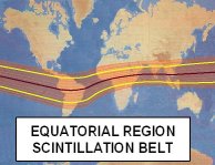
Ionospheric disturbances can cause rapid phase and amplitude fluctuations of satellite signals observed at or near the earth's surface; these fluctuations are known as scintillation. The most intense natural scintillation events occur during nighttime hours within 20o of the earth's magnetic equator, a region encompassing more than 1/3 of the globe's surface. Scintillation affects radio signals up to a few GHz frequency and seriously degrades and disrupts satellite-based navigation and communication systems. SCINDA was designed to provide regional specification and short-term forecasts of scintillation activity to operational users in real-time. 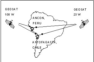
The SCINDA system concept is presently being demonstrated using two stations in South America. Scintillation parameters from available UHF (FLTSAT) and L-band (GOES, GPS) satellite links and ionospheric drift velocities are measured and stored at the remote sites. At fifteen minute intervals the reduced parameters are retrieved via internet to Hanscom AFB, where they are used to drive a semi-empirical model which produces simple three-color graphical representations of large-scale equatorial scintillation structures and associated communication outage regions. 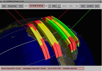
Visualization tools aid the operator in understanding the development of the scintillation structures and determining strategies for maintaining reliable communications. For example, based on the sample data displays shown here, a user near Antofagasta, Chile would find his communication link, represented by the red line from the ground to the western sky in the figure, disrupted by the presence of scintillation. The expanded view shown in the second image, however, shows very clearly how communications may be clear between the discrete scintillation structures when using the satellite to the east. In this case, communications may be maintained simply by re-pointing the user's antenna. 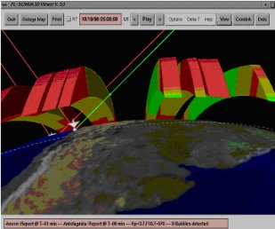
SCINDA provides a friendly graphical interface allowing the operator to easily define a desired communication link, which includes ground-station coordinates, radio frequency and a comprehensive satellite database, complete with daily ephemeris updates. The model then displays the communication links between the ground stations and satellites, color-coded green if clear, and red if the link passes through a scintillation structure. While 3D maps are useful for visualization purposes, SCINDA generates 2D communication outage maps for SATCOM users. 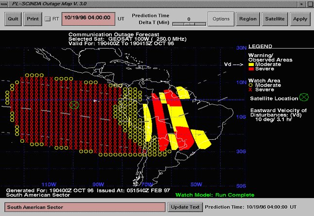
Outage maps are generated for operational purposes. The outage regions are frequency-corrected geometric projections from a selected satellite to the ground. To first order, this is like placing a flashlight on the satellite and if an observed bubble would cast a shadow, then it will appear on the map. "Warning" areas, plotted in solid colors, are based on the current location of observed disturbances, while "Watch" areas, delineated by x- and o-symbols, are derived by adjusting climatological activity levels, based on WBMOD, to be consistent with current observed levels. This provides a powerful tool for expanding specification beyond the region of actual observations, particularly to the west of ground-based sensors where meaningful predictions would be otherwise impossible due to the eastward drift of observed scintillation features. Scintillation intensity in both the Watch and Warning areas is displayed using the same simple three-color mapping scheme employed in the three-dimensional view. If the operator sets the color map thresholds properly for a given user, the red-yellow-clear areas can be immediately interpreted as regions of severe , moderate and little effect on his specific system, respectively. Information regarding the scintillation structures' evolution is employed by the model to generate "nowcast" projections of scintillation activity up to three hours in advance. Hardcopy and electronic image format outputs are supported to facilitate getting the information to the user as soon as possible. 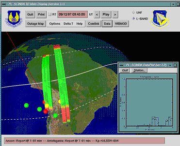
AFRL-SCINDA is currently incorporating the ability to map L-band scintillation structures. Receiver sites are now equipped in South America and model development is in progress. L-band signals from the NOAA GOES satellite and the GPS constellation are used to form a consistent composite representation of scintillation regions, as shown in the figure to the right. During the current low level of solar output, the scintillation levels for L-band communication signals are relatively benign. As the solar cycle proceeds and activity from the sun increases, however, L-band signals will be severely affected. The specific impact on GPS navigation and other applications is currently under investigation at AFRL with the goal of producing accurate "navigation error" outage maps to support DoD operations during the next solar maximum. 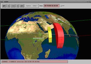
Current plans include expansion of the network to new geographic regions, including SE Asia and the Middle East. In January 98 a new station was established at Ascension Island. Stations in SE Asia should be operating in FY99 in collaboration with Australia; Middle East sites are also planned in FY99. SCINDA is currently installed at 55 SWXS, Peterson AFB for prototype operational evaluation. SCINDA was developed at Air Force Research Laboratory, VSBI under the direction of: Dr. Santimay Basu, Dr. Keith Groves, Capt. Matt Smitham and Dr. Edward Weber. For more information on SCINDA, contact:
SCINDA Home Page |